1970 FAA2068 CAPE HATTERAS
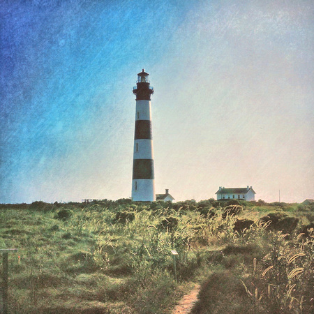
Cape Hatteras Lighthouse
Outer Banks
Hatteras Island
Buxton NC
1970
Cape Hatteras Light is a lighthouse located on Hatteras Island in the Outer Banks in the town of Buxton, North Carolina and is part of the Cape Hatteras National Seashore. The lighthouse’s semi-unique pattern makes it easy to recognize and famous.
The Outer Banks are a group of barrier islands on the North Carolina coast that separate the Atlantic Ocean from the coastal sounds and inlets. Atlantic currents in this area made for excellent travel for ships, except in the area of Diamond Shoals, just offshore at Cape Hatteras. Nearby, the warm Gulf Stream ocean current collides with the colder Labrador Current, creating ideal conditions for powerful ocean storms and sea swells. The large number of ships that ran aground because of these shifting sandbars gave this area the nickname "Graveyard of the Atlantic." It also led the U.S. Congress to authorize the construction of the Cape Hatteras Light. Its 198-foot height makes it the tallest brick lighthouse structure in the United States and 2nd in the world. Since its base is almost at sea level, it is only the 15th highest light in the United States, the first 14 being built on higher ground.
Cape Hatteras is a cape located at a pronounced bend in Hatteras Island, one of the barrier islands of North Carolina. Long stretches of beach, sand dunes, marshes, and maritime forests create a unique environment where wind and waves shape the topography.
Cape Hatteras has long been known to mariners as the "Graveyard of the Atlantic." Its fame and reputation, however, come not from the cape itself, but from the succession of ever-shifting underwater sandbars, known collectively as Diamond Shoals, that extend seaward to the very edge of the Gulf Stream.