1970 FAA2077 GODFREY GLEN
Crater Lake National Park
Klamath County OR
circa 1970
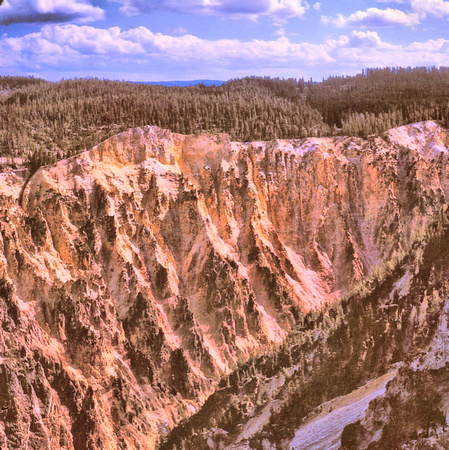
Godfrey Glen is a flat area at the lower end of the valley of Munson Creek, a tributary of the larger Annie Creek, which parallels the road to the south entrance of Crater Lake National Park, running through a deep, V-shaped ravine bordered by light-colored volcanic rocks. The Godfrey Glen Trail loops around a wooded promontory between the two creeks; the first stretch affords good views of the narrow Munson drainage, lined for several hundred feet by a straight wall of scoria, partly eroded into columns; similar to the more well-known Pinnacles to the east.
The latter stages of the trail wind around a tributary of Goodbye Creek (which meets Annie Creek just downstream), also cutting through volcanic rocks, here rather softer but equally lacking in vegetation. Although short, the path has a good variety of views and so is quite popular, one of two routes close to the southern national park entrance station at Mazama Village.
Crater Lake National Park is in the Cascade Mountains of southern Oregon. It’s known for its namesake Crater Lake, formed by the now-collapsed volcano, Mount Mazama. Wizard Island is a cinder cone near the western edge of the lake. The Rim Drive, a road surrounding the lake, offers views of the park’s volcanic formations. The park’s numerous trails include Sun Notch, with views of the Phantom Ship, a small island.
https://www.nps.gov/crla/index.htm